
#1 Koshi River
The Kosi or Koshi is a transboundary river which flows through China, Nepal and India. It drains the northern slopes of the Himalayas in Tibet and the southern slopes in Nepal. From a major confluence of tributaries north of the Chatra Gorge onwards, the Kosi River is also known as the Saptakoshi (Nepali: सप्तकोशी, saptakoshī) for its seven upper tributaries. These include the Tamur River originating from the Kanchenjunga area in the east and Arun River and the Sun Kosi from Tibet. The Sun Koshi's tributaries from east to west are the Dudh Koshi, Likhu Khola, Tamakoshi River, Bhote Koshi and Indravati. The Saptakoshi crosses into northern Bihar, India where it branches into distributaries before joining the Ganges near Kursela in Katihar district.[1] The Koshi is the third-largest tributary of the Ganges by water discharge after the Ghaghara and the Yamuna.
The Kosi is 720 km (450 mi) long and drains an area of about 74,500 km2 (28,800 sq mi) in Tibet, Nepal and Bihar.In the past, several authors proposed that the river has shifted its course by more than 133 km (83 mi) from east to west during the last 200 years. But a review of 28 historical maps dating 1760 to 1960 revealed a slight eastward shift for a long duration, and that the shift was random and oscillating in nature.
#Gandaki River
The Gandaki River, also known as the Narayani and Gandak, is one of the major rivers in Nepal and a left-bank tributary of the Ganges in India. Its total catchment area is 46,300 km2 (17,900 sq mi), most of it in Nepal. In the Nepal Himalayas, the Gandaki is notable for its deep canyon. The basin also contains three mountains over 8,000 m (26,000 ft), namely Dhaulagiri, Manaslu and Annapurna Massif. Dhaulagiri is the highest point of the Gandaki basin. In its upper reaches, the river is known as Kali Gandaki ( or Gandaki) as it flows through the Mustang district and the famous Kali Gandaki Gorge in Nepal. When the river reaches the Terai plains of Nepal, it is referred to as the Narayani River. This name change typically occurs near the confluence with the Trishuli River at Devghat in Chitwan. Upon entering India, the river is known as the Gandak River.
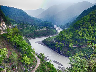
#Karnali River
The Ghaghara River, also known as the Karnali River in Nepal, Mapcha Tsangpo in Tibet, and the lower Ghaghara in Awadh is known as the Sarayu River,[1] is a perennial trans-boundary river that originates in the northern slopes of the Himalayas in the Tibetan Plateau, cuts through the Himalayas in Nepal and joins the Sharda River at Brahmaghat in India. Together they form the Ghaghara River, a major left-bank tributary of the Ganges. With a length of 507 km (315 mi), it is the longest river in Nepal. The total length of the Ghaghara up to its confluence with the Ganges at Revelganj in Bihar is 1,080 km (670 mi).[2] It is the largest tributary of the Ganges by volume and the second largest by length after Yamuna.
#Mahakali River
The Mahakali River that originates in the northern Part of Limpiyadhura elevation of 6,180 m in the Darchula District. It then flows between the Nepal and India border.[2] Descending, it enters the Indo-Gangetic Plain at Brahmadev Mandi in Nepal, where it expands above the Sharda Barrage. From that point onward, it is known as the Sharda River. The river proceeds southeastward into India through northern Uttar Pradesh before merging with the Ghaghara River southwest of Bahraich, covering a distance of approximately 300 miles (480 km).[1][3]


Comments (0)
No comments yet. Be the first to comment!